
Traffic Assignment: Analysis For Haughton Road
Question
Task:
This report aims to investigate the traffic design of your study area. It should begin by providing
a brief summary description of the study area (do not assume the reader has read Assignment
1). Unless discussed with the lecturer, use the same study area identified in Assignment 1
for this report.
Report Content
The report must address the following questions.
1. Choose a short segment of road in your study area and categorise it using the Link and
Place framework. Justify why you classified it this way. Does this classification result
in any conflicts between the road link and place functions?
2. Choose a small residential section (such as an apartment building or a residential street)
in your study area. Using trip generation rates from two different sources, how many
trips should this residential strip attract? Make sure you mark out the residential area
on your map and show your calculations. Do the estimated trip generation rates differ?
Which is likely to be more accurate? Given your knowledge of the local area, do you
think the estimated trip rate(s) are accurate? If so, why? If not, why not?
3. Choose a parking lot in your study area. Given the surrounding land-use(s) that the
parking lot serves, determine the parking demand. Propose an appropriate design
(including specifying the quantity and type of parking) and management (including
price and time controls) for this parking lot.
4. Conduct a safety assessment of your study area using existing crash records. Detail the
major traffic conflict locations and discuss potential traffic engineering solutions.
5. Choose two out of these four transport modes: trucks, on-road public transport,
pedestrians and cyclists. Is the traffic system designed appropriately for these users?
What design changes would you propose to better accommodate these users?
6. Conclude your report with a summary of the most significant issues impacting the
safety, efficiency or amenity of the traffic system in your study area. Include proposed
solutions to these issues.
Answer
Introduction
Brief description of study area explored in the traffic assignment:
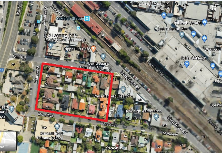
The study area explored in the present traffic assignment is situated in Oakleigh, Victoria in the outskirts of Melbourne as illustrate in the Figure 1 below. The main modes of transport in the area are rail track, cycling pathways and road networks, which are majorly tarmacked as illustrated in Figure 1 of traffic assignment. The road networks include both public and private means of transport. However, the public traffic road networks are separate from the private traffic road-networks (Jones, Marshall, & Boujenko, 2008). Warrigal Road, one of the main transport spines, is a dual carriage road that accommodates private and public bus transport. Feeder roads in the area branch off Warrigal Road, Haughton Road (that is adjacent to the rail track), Portman Street and Hannover Street, the main roads that accommodate both public and private transport. The feeder roads are mainly for private transport. The main walking and cycling path in the area is the Djerring trail, that is positioned adjacent to the Dandenong Train line, as shown in Figure 1 presented below within this traffic assignment:
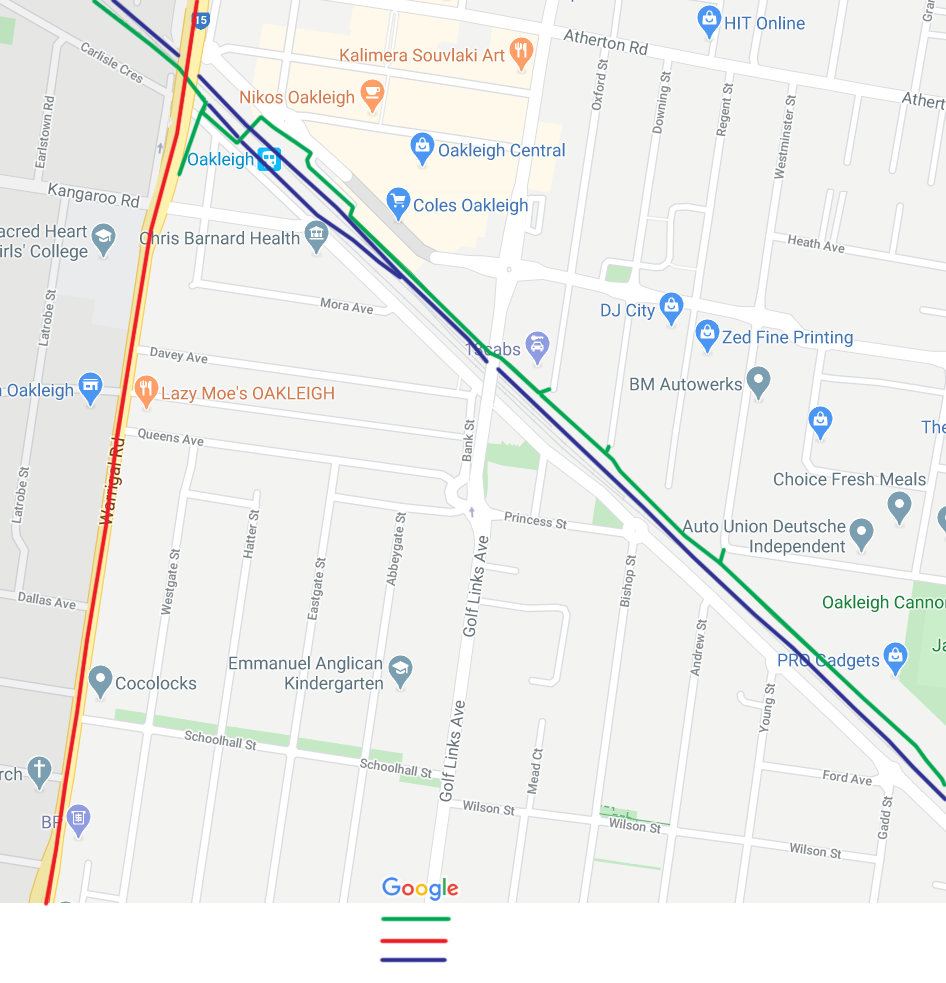
Figure 1. Study area, Oakleigh, Victoria Source: (Google, 2020)
1.0 Categorization via link and place framework
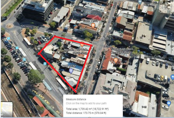
The road chosen for this segment of traffic assignment is Haughton Road. The criteria for selection were based on the variety of the street activities within the vicinity and accommodation of public and private traffic. The chosen link selected to prepare this traffic assignment from Johnson Street to Haughton road causes safety conflicts considering the fact that many pedestrians cross this road to board the train making it a busy crossing road hence the reason why there are pedestrian crossing marks. The section for review done within this traffic assignment is illustrated in the Figure 2 below.
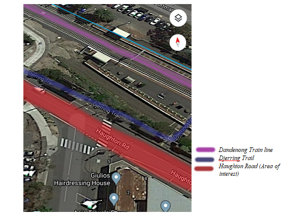
Figure 2. Area of interest: Section of Haughton Road. Source: (Google, 2020)
The link-and-place framework provides a two-dimensional classification system that may be used for any type of road present in the urban matrix (Jones, Marshall, & Boujenko, 2008). In order to categorise the road according to the link and place framework, the following considerations were made within this traffic assignment:
- Road classification: The road may be deemed as a district street, as shown in Figure 3
- Link function: This aspect mentioned in this traffic assignment refers to the connectivity function of the road; the degree to which the road provides seamless connection with the minimum possible disruptions(Nielsen & Lange, 2012). Haughton Road offers a conduit for public and private vehicular traffic. In addition, at that section of the road, the Djerring Trail is positioned adjacent to the road, thus offering a resourceful conduit for cyclists and pedestrians (Nielsen & Lange, 2012). The section also contains the Oakleigh train station that allows locals to use the railway. All the transport links provide connectivity across major townships in the Melbourne suburbs. Consequently, the section may be considered to have a district link function.
- Place function: This designates the street as a destination; the activities or features adjacent to the street that provides places for interests, especially for pedestrians. The reviewed section of road considered in this piece of traffic assignment has landscaped regions that separate the trail from the tarmacked road, that act as a boulevard, parking bays and retail shops and parlours at the intersection(Nielsen & Lange, 2012). Owing to the named place functions, the reviewed section may be deemed to have a neighbourhood place function.
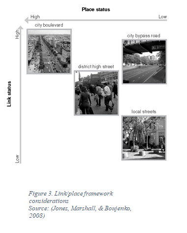
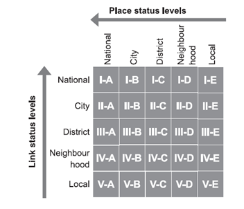
Figure 4. The five by five street link/place sorting matrix.
Source: (Jones, Marshall, & Boujenko, 2008)
In conclusion, the section may be considered to have a district link-function, and a neighbourhood place function. Subsequently, according to the five-by-five matrix shown in Figure 4 provided above within this traffic assignment, the section may be categorised as III-D. This classification may arise some conflicts between the road link and place functions; due to variety of connectivity links at the section it may be expected to have more retail place functions and a larger boulevard than the one currently existing, as seen in Figure 2.
2.0 Trip generation for a residential area
Trip Generation of an area aims at predicting amount of trips by generating their (trips) frequencies based on networks of transportation in given area of study (Weinberger et al., 2014: Community Design and Architecture Inc, 2012)). Being the first stage in the four procedures of transport forecast, trip generation analysis, and prediction is mainly supported by factors of traffic and modes of travelling. It is estimated by comparing trip frequency and travelling characteristics of residents in the study area. Based on the degree of geographical gathering, distinct models of trip generation can be applied (such as regression and cross-classification) (Weinberger et al., 2014). Trip generation models can be useful to travellers, visitors, and tourists for recreational and research purposes both in the transport sector and information centres. Trip generation of an area helps analyse and forecast future demands of urban traffic in a given region, which mainly relies on the improvement of transport development policies and the town’s economic status.
The residential area reviewed for this section is shown in below within this traffic assignment. The trip generation rates for this section are sourced from Institute of Transportation Engineers’ (ITE) entitled Trip Generation, 7th edition (Weinberger et al., 2014).
Traffic impact is always required for a particular development to generate significant human traffic and vehicular traffic in the residential area. The main purpose of traffic impact analysis is to get frequency of a street to accommodate the right of way to generate trip analysis of the proposed area. The impact of traffic will help identify the potential mitigation measures that can be proposed on site. This will help the developers to assess whether the drive ways available are necessary or they can be redirected while providing the locals with private roads to access their property. The analysis done in this section of traffic assignment is used to estimate AM and PM peak hour’s trips to determine whether they are greater than 100 trips/hour (Weinberger et al., 2014). our chosen residential site mainly experience private vehicular and human traffic from Mora Avenue and Johnson Street with heavy traffic experienced during peak hours in the morning and evening.
Process for Calculating Trip Generation
Data required to calculate trip generation include;
- Land use
- Number of units
- Gross Square Footage
The trip generation of the proposed land of residential area consist of 0.75 hectares.
|
Code |
Anticipated Land use |
Acres |
GFA |
No of units |
AM Peak |
PM Peak |
|
210 |
Single Family Detached Housing |
1.84 |
n/a |
16 |
15 |
19 |
|
TOC |
ITEL and use |
Known |
Known |
87 |
88 |
Traffic Impact Assessment is not required in the case since both AM and PM contribute less than 100 during peak hour trips.
The table below presented in this traffic assignment shows trip generation information for residential area development in Oakleigh in Victoria area for weekdays (AST, Peak hour – PM and Peak hour - AM)
Table 1: Trip Generation Rates
|
Development |
ITE Code |
Basic Unit For Trip Generation |
Weekday (ADT) |
Peak Hour (A.M) |
Peak Hour (P.M) |
Units For 100 Peak Hour Trip |
|
Detached Houses |
220 |
Dwelling units |
2.12 |
0.15 |
0.19 |
150 |
The estimated trip rate is accurate due to the low trip rates experienced in the residential spaces as shown in table 1 above within this traffic assignment
3.0 Parking Design and Demand
Choose a parking lot in your study area. Our site area faces the main challenge in parking spaces leading to congestion in streets area by having road side parking. As a result, traffic jam is bound to occur leading to time wastage and pollution of the environment in such circumstances. This occurrence makes the roads in the area to become unreliable during peak seasons. The high number of vehicles in the area is contributed by the fact that our site acts as the central point for most mode of transport with the availability of bus stations and Oakleigh railway station. Therefore, locating land in for parking space is also a challenge that the designers have to deal with due to its scarcity and almost every part is developed. Therefore, drastic and strategic measures must be taken to ensure that the proposed parking is implemented. As such, I sort out to design a parking silo that will be sustainable considering the increasing trend in people who own vehicle each year (Nielsen & Lange, 2012). Thus, a parking silo of 6 floors can help solve some of the haphazard parking problems in Oakleigh area. As stated in this traffic assignment, the proposed site allocated for the design is bordering Chester to the north, Station Street to the east, and Portman Street to the south as shown in the map below. Before redeveloping our parking lot, businesses on site will have to relocate before demolition takes place. The developer will have to acquire the demolition certificate from the local authority to commence with the work.
The surrounding land use around our parking lot mainly serves commercial buildings, and Oakleigh rail station. This land mentioned in this traffic assignment uses always experience a surge of people every day because of transport services and businesses that act as the driving force to the economy. As such, people move around Oakleigh with cars on a daily basis for business matters. Therefore, it is prudent to have a parking space around the area to help solve the demand for parking. The department of transport in Oakleigh, Victoria in their 2019 report predicted that in the next 10 years, the same 250 cars in the area during peak hours will multiply by 1.5, a give or take situation, which brings the number to 250 *1.5 = 375 cars. The current demand to supply ration is 250 cars/200 spaces offered during peak hours is 1.25.thus, parking lot is urgently required to help address the shortage to ease traffic and congestion in the area.
Propose an appropriate design (including specifying the quantity and type of parking) and management (including price and time controls) for this parking lot.
The proposed parking silo will be a six storey building with a basement floor accommodating 42 parking spaces in each floor having 90 degrees parking spaces as shown in the typical layout plan below within this traffic assignment. The parking plinth area is 44m x 34m. The parking will be managed by the local authorities and each parking space will go for 4AUD. The fee collected from the parking services will help in maintenance purposes while the taxes paid spur the economic growth in the region.
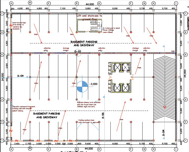
Figure 5: Typical Layout Plan
The parking silo will provide approximately 294 spaces for employees working in the railway station, and those working in the commercial buildings around the site. The parking spaces allocated is accessible for ADA spaces. With regards to the challenges in parking spaces, it will be prudent to charge parking spaces to generate income and expense duties for its users.
Various researches conducted in the area explored in this traffic assignment helps to understand the modes of travel adopted by travelers and employees. A large number of people use rail transport followed by those that use cars and shuttle services (Jones, Marshall, & Boujenko, 2008).
4.0 Safety assessment of the study area
Road safety management process identifies road safety problems, devising the mitigation strategies, selecting and implementing these strategies to solve the safety problems. The safety management is proactive and helps to prevent the safety problems before they occur. High quality data on safety problems are used to determine the state of the road safety and the best way that they can be solved. Australian road safety records state that many traffic related accidents occur due to mistakes made by the road users involved. However, the critical element with these accidents lies behind the reasons for the mistakes. It remains transparent that road layouts and planning play critical roles in such accidents either directly through provision of incorrect information or indirectly through misinterpretation of the situation. Also, there exist numerous examples of design regulations that may decrease the number of mistakes leading to risks and accidents. These design measures usually lower chances of the road users to make mistakes and in case the mistakes happen, making the surrounding exceedingly forgiving. However, the existing problem remains difficulty in predicting how road users shall react to the changes in the physical environment. Many examples considered to prepare this traffic assignment show how “engineering effect” of a measure varies with the “actual effect”. The real safety effect is usually low and may cause a rise in accidents. Behavioural adaptation usually summarizes the underlying phenomenon.
Thus, road users usually change their behaviour to their notion about the new situation. The obvious adaptation is the feeling of road users that safety has been improved leading to nonchalant behaviour that leads to high speeds. A current research on traffic assignment in Finland gives a proper illustration of the problem. The adoption of reflector poles on rural roads was carried out to improve visual guidance in the dark for drivers; thus, making them not to drive off the road. Also, the findings demonstrated that driving speeds generally increased in darkness leading to an increase in injuries by approximately 60%.
The reason for carrying out a conflict analysis on a road intersection happens when there is doubt of what to do with the junction. Conflicts are categorized into moderate, dangerous and critical conflict. On the junctions mentioned in this traffic assignment, conflicts were recoded after and before the installation of the traffic signs.
The most common problems associated with traffic flow in an urban setting are traffic noise, pedestrian vehicular conflict and visual intrusion. This particular section will carry out a safety assessment on three intersections along Haughton road in Oakleigh VIC 3166, Australia. As discussed in unit CIV5302, the common and usual occurrences of road safety conflicts are crash data. These data can be used to identify the moderate to critical cases of safety problems to help in the drafting of construction solutions to combat the conflicts encountered in intersections. Other data, such as traffic volume, roadway characteristics, driver history, and citations can be incorporated with data from previous crash records in identifying safety trends and high prone locations.
Table 2: Accident Records along Haughton road in Oakleigh
|
Total: 86 casualties |
Main accident types |
Accident time of the day |
Major accident cause |
|
Fatal: 0 |
Pedestrian to vehicle: 9 |
24 – 4 hour: 35% |
Signal violation: 33% |
|
Serious injury: 35 |
Head on collision: 10 |
14 – 20 hour: 28% |
Unsafe maneuvering: 46% |
|
Light Injury: 51 |
Head to tail collision: 18 |
Speeding at night in general |
|
|
90 degree collision: 12 |
|||
|
Collision by Lane changing: 9 |
Evaluation Tools
As discussed in this traffic assignment, accidents analysis will remain to be a significant tool in safety management as accidents occur due to a poor safety situation. However, accident analysis is not much useful in the evaluation of locally applied procedures. Thus, the number of accidents remains very small coupled with biased reporting and uninformative events that lead to accidents. It can be alleged that accident analysis represents a “desk tool” carried out indoors devoid of any connection to the happenings on the street. The shortfalls in accident analysis can cause the usage of behavioural analysis. Additionally, studies utilized in this traffic assignment indicate that jaywalking can remain distinct with varying related risks. Hence, it is essential to comprehend the problem to ensure the introduction of feasible countermeasures.
Major traffic conflict locations in our study area
There is a road intersection of approximately 45 degrees directed from Johnson Street to Haughton road. Although, safety measures have been put in place in this particular junction with a visible zebra crossing available, more intervention on safety need to be implemented considering the number of minor accidents that has taken place at this location to help save lives.
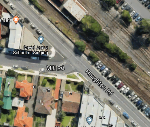
The second location portrayed in the section of traffic assignment that experience traffic conflict is located on the drive way that links Mill road and Haughton road as shown in the image below. Lack of mitigation measures at this point has raised concerns on safety measures on this road hence the need to incorporate engineering solutions to reconstruction the road to avert more conflicts in future.
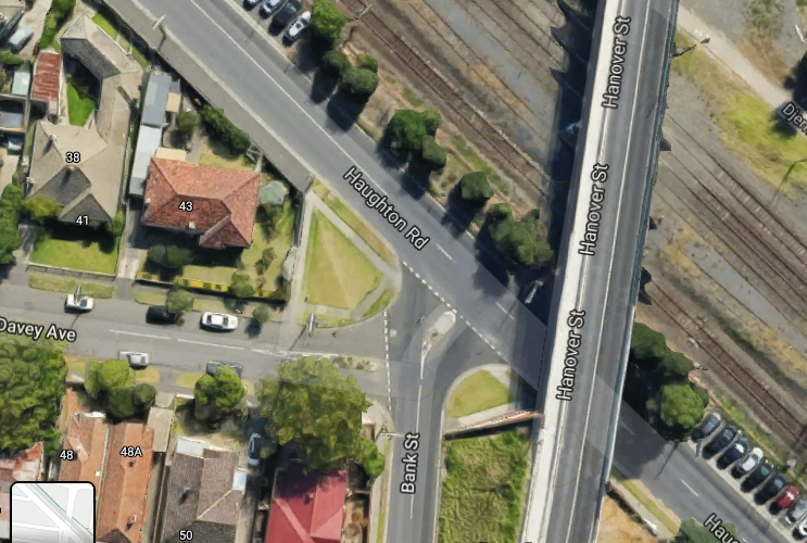
The third location provided in this traffic assignment is situated in the junction converging two roads from Davey Avenue and Bank Street joining Haughton road. Serious intervention is needed to help solve the safety issues at this intersection to avert accident incidences.
What are the causes of road accident in our study area explored in this traffic assignment?
There are various reasons that lead to the occurrence of road accidents. These include:
- Road users: failure to follow traffic rules, rash drives, failure to perceive traffic signs or situations, fatigue, carelessness, driving under the influence of alcohol etc.
- Road condition: potholes, skidding road surfaces, mirage
- Vehicle: unroad worthy vehicles, defects on lighting system, tyre burst, brake failure
- Road design: poor design in geometric design, improper curve design, sight distance, defects in lighting
- Environmental conditions: unfavorable weather like mist, smoke, snow, and rain can corrupt drivers visual acumen hence making driving unsafe
Road reconstruction
The number of vehicles flooding our roads each is alarming. This surge of vehicles creates complication and confusion in our roads causing problems in traffic and reducing the time to reach destinations during peak hours in the morning and evening and such transportation characteristics along Haughton road leads to the growth of accidents. As such, there is need for reconstruction of the road. The road needs to be carefully planned and marked to ensure that it is well visible. The google maps images attached above shows the three different conflict points causing confusion to drivers and pedestrians although in the first location there are pedestrian crossing way that makes it easy for them. Nevertheless, there are other challenges encountered at this junction. The reconstruction process will include the construction of pavements directing traffic, realigning the profile of the existing road to allow for seamless drive into the main road, Haughton road, to improve traffic safety. The main objective of the reconstruction outlined in this section of traffic assignment was to direct the secondary roads into the main stream traffic. In addition, the use of traffic signs will be necessary to control traffic. A little alteration of the road section will be necessary to help resolve the smooth flow of vehicles in an organized manner.
Channelization
The traffic at the three intersections will be redirected to the main stream by offering separate lanes for convenience of paths that spread to a point of conflict located between different traffic streams. The three intersections will be reconstructed following the below traffics separated by markings provided in this traffic assignment.
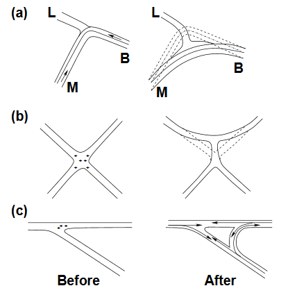
Figure 6: Road Reconstruction techniques
The principles of channelling the intersection are discussed in the next section of traffic assignment:-
- The intersection layout should be visible, and easy to understand by drivers
- Pedestrian crossing is necessary
- Using roads kerbs on both ends with markings to separate lanes
- Separating the high ways express through turning traffic flow
- The width of traffic lanes should be sufficient for all manner of vehicles.
- Using road signs that is known by drivers
Road signs
Road signs play an integral part in ensuring road safety, warning drivers to adhere to road safety rules to protect pedestrians and drivers from accidents that could be avoided. The signs mentioned in this traffic assignment should be visible for drivers to read them from a far and enough to understand and respond to them immediately. Essentially, the signs must have the correct colour, shape and in strategic position. In addition, they must be well maintained to ensure that they last for long because without maintenance, they might not serve their purpose successfully. According to the British Investigation height, road signs texts should follow the formula below;
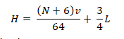
Where N = number of words on the signs
V = speed of vehicles measured in Km per hour
L = distance in meters from which inscription should be visible
5.0 Review of the transport modes in the study area
Review of the on-road public transport network
The main road in the area is the Warrigal road. It is a dual-carriage way that branches off into spine roads such as Haughton Road, Golf-links road and School Hall Street that branch off to smaller feeder roads that circulate through the residential estates, which feature private vehicular traffic. The on-road public network comprises the previously named roads and the Warrigal Road. (Nielsen & Lange, 2012). The public on-road network may be deemed to have met the legislative and design requirements satisfactorily due to the following factors:
- The roads follow a regional organisation structure: the roads area arranged in such a way that they follow a hierarchy of function. The Warrigal Road has the highest function in the area, being a dual-carriageway, it accommodates the most public traffic in the area, which feed into the feeder roads(Community Design and Architecture Inc, 2012). The feeder roads are second in function, being single lane routes that accommodate less public transport and more private transport.
- The routes are quite simplified, with the major roads having no intersections while the feeder roads having roundabout intersections that are designed to accommodate the traffic from the residential areas.
- Parking bays have been provided along the dual-carriageway and the feeder roads. These parking bays are located at the relatively public intersections, away from the residential neighbourhoods.
The public on-road network may be improved by applying the following action steps illustrated in the traffic assignment:
Review of the pedestrian transport facilities
Pedestrian lanes have been provided on either side of the tarmacked roads. The area also includes a road dedicated to pedestrians known as the ‘Mona Walk’ that is marked in the Figure 6 below (Marshall, Arts, & Morrison-Saunders, 2005). Pedestrian paths are vital to these areas, especially because it is largely a residential area that features estate neighbourhoods. In addition to being a mode of transport in the estates, it is also a preferred mode for exercise and recreation. It is estimated that 44% of adults, especially in city suburbs, walk as a form of exercise (Blomberg, Jordan, Killingsworth, & Konheim, 2016). As illustrated in Figure 6 below, majority of these paths are located just outside the residence’s yards, and are separated from vehicular traffic by landscaping that is roughly 1.2m to 1.5m wide as shown in Figure 7 below.
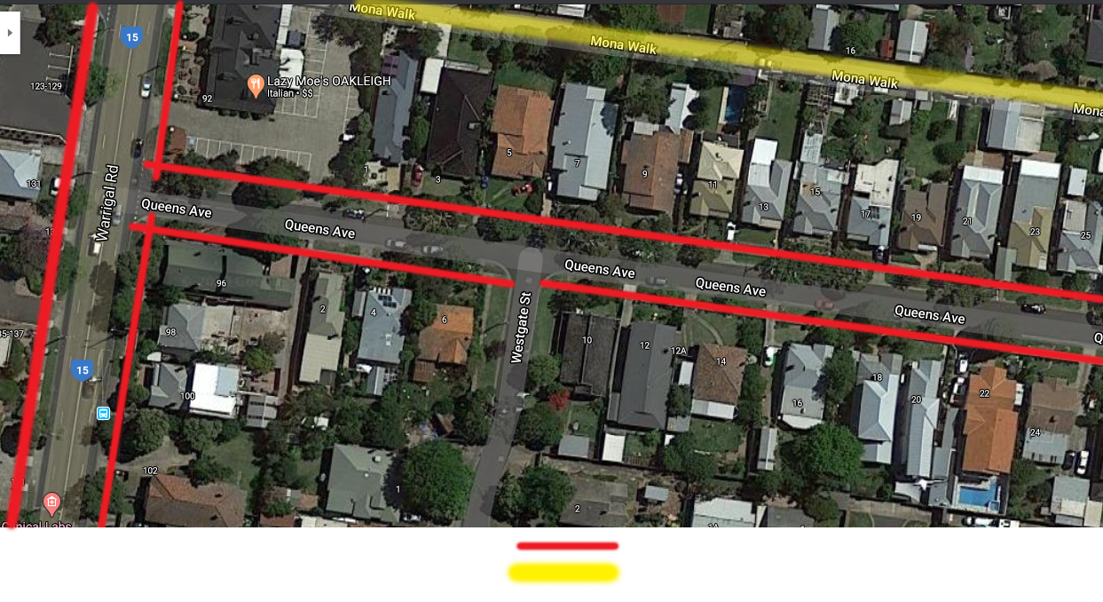
Figure 7. Identified pedestrian paths and walks in the area. Source: (Google, 2020)
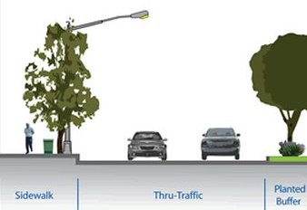
Figure 8. Typical section of the sidewalk vis a vis vehicular traffic.
Source: (Blomberg, Jordan, Killingsworth, & Konheim, 2016)
The current design developed within this traffic assignment enables a buffer zone between the pedestrian and vehicular traffic. These buffers involve landscaping, often grass that is dotted with a number of trees. By screening the walkways, the design achieves an attractive pedestrian path that is screened off, providing its users a negotiated privacy as illustrated in Figure 9 below. More action can be done by using the traffic calming effect (Jones, Marshall, & Boujenko, 2008). This involves tailoring streets to multimodal use by slowing the vehicular traffic in order to minimise the risks to all users on such streets. This may be implemented by the installation of gentle bumps. In addition, major steps can be taken to incorporate the needs of seniors, children and people with special needs. This aspect noted in this traffic assignment can be achieved by the placement of proper road signage, easy crossings at the streets and designing the streets to accommodate the human scale. Further steps that may be taken include:
- Installing a mix of complimentary activities and services at manageable walking lengths to improve interest for the pedestrian. Typical walkable lengths often range between 400m to 600m. These activities may include; benches, squares, courtyards or plazas.
- Providing safe transitions for pedestrians across the streets by having shorter crossings, thus offering the pedestrian a stronger visual connection
- Providing street lighting for use during cloudy weather or the evenings
- Designing the transition space between the private residence driveway and the pedestrian path, to minimise risk to both users.
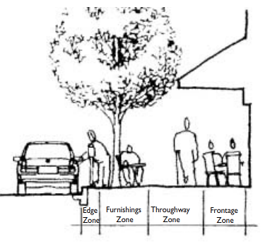
Figure 9. Typical pedestrian sidewalk zones.
Source: (Community Design and Architecture Inc, 2012)
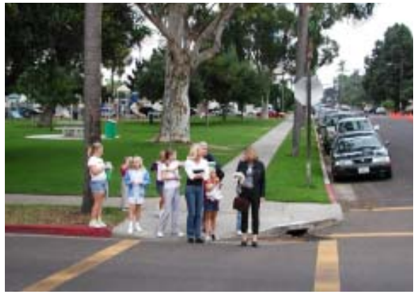
Figure 10. Typical pedestrian path in the area.
Source: Author
Due to the lack of cycling paths within the estates, cyclists often opt to use the pedestrian path instead, putting pedestrian at a very high risk. Consequently, cyclists’ path ought to be demarcated and adequately marked from the pedestrian’s walkway.
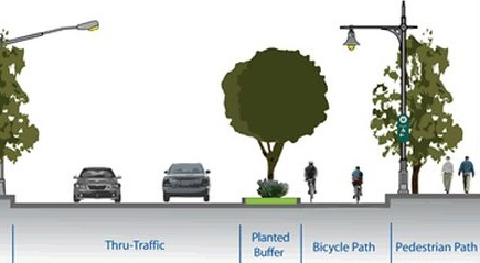
Figure 11. Recommended design with a separate cyclist path and pedestrian walkway.
Source: (Jones, Marshall, & Boujenko, 2008)
Recommendation
Improving the road linking to Haughton Road
- Ease traffic congestion on Haughton Road enhancing journey times due to their reliability;
- Facilitate the facilities for cyclists, pedestrians and equestrians;
- Facilitate the local economic growth of local road users
- Separating the local traffic from long distance traffic by keeping the right traffic on the right road
6.0 Conclusion
Most significant issues impacting the safety, efficiency or amenity of the traffic system in your study area, and the proposed solutions to these issues.
The study area is located in Oakleigh, Victoria, in the outskirts of Melbourne. The study area has four modes of transport namely train trucks, road public and private transport, cycling track and pedestrian. A small section of the Haughton road was reviewed for its link/place classification. This section of traffic assignment was found to have a district link function and a neighbourhood place function, thus was classified as III-D road.
On-road public transport and pedestrian modes in the study were reviewed. The on-road public transport was found to have adhered to the minimum regulations
The pedestrian design of the study area was found to have attained the minimum design and legislation standards: they were located adjacent to the estate vehicular traffic with buffer zones, and covered between 1.2m and 1.5m widths. In addition, the area had a dedicated road for pedestrian use referred to as the ‘Moon Walk’. Although the design may be sufficient, further action may be taken to improve the safety and efficiency of these pedestrian paths, especially because they are located in residential neighbourhood. These include: providing a separate cyclists path, slowing the vehicular traffic by use of gentle or ripple bumps, installing the proper signage, installing complimentary activities or services at walkable lengths such as benches or courtyards, provision of shorter and safer pedestrian crossings and provision of street lighting.
References
Blomberg, R., Jordan, G., Killingsworth, R., & Konheim, C. (2016). Pedesretain transportation: A look forward (2 ed.). Traffic assignment New York: Cambridge Systems Inc. http://onlinepubs.trb.org/onlinepubs/millennium/00047.pdf
Community Design and Architecture Inc. (2012). Model Guidelines for the San Diego Region. In SANDAG, Planning and Designing for Pedestrians (pp. 35-80). San Diego: Mahandram Publishers. https://www.sandag.org/index.asp?subclassid=98&fuseaction=home.subclasshome
Google. (2020). Google Maps. Retrieved 05 28, 2020, from www.googlemaps.com
Jones, P., Marshall, S., & Boujenko, N. (2008). Creating more people-friendly urban streets through 'link and space' street planning and design. In P. Jones (Ed.), Aiming for a Better Road Traffic Environment (pp. 57-90). London: Oxford University Press. https://doi.org/10.1016/S0386-1112(14)60196-5
Kim, K. J., & Sul, J. (2009, September). Development of intersection traffic accident risk assessment model. In 4th IRTAD Conference. http://citeseerx.ist.psu.edu/messages/downloadsexceeded.html
Marshall, R., Arts, J., & Morrison-Saunders, A. (2005). International principles for best practice EIA. Principles for EIA follow-up, 1(45), 175-190. https://doi.org/10.3152/147154605781765490
Mathew, T. V., & Rao, K. (2006). Transportation Engineering I. Mumbai, India: Civil Engineering–Transportation Engineering. IIT Bombay, NPTEL ONLINE.
Nielsen, G., & Lange, T. (2012). Network DEsign for Public Transport Success- Theory and examples. London: Adventure Press. http://civitas.no/assets/nielsenlangethredbo10paper.pdf
Weinberger, R., Ricks, K., Schrieber, J., Cohen, L., & Symmetra Design, L. L. C. (2014). Trip generation data collection in urban areas (No. DDOT-RDT-14-01). District of Columbia. Traffic assignment Dept. of Transportation. https://rosap.ntl.bts.gov/view/dot/28280